Home

Sky Gods and Plumed Water Serpents | A Red and White Theory | The Caribbean | South America and Central America | The Impact of Impact | 360 Degrees in a Year | Precession of the Earth's Axis | Celestial Hemisphere | Alluvial Fans, Floods and Salmon | Links | Feedback | Impact Calculations
Clear up for Bremfrost
Coming To Light

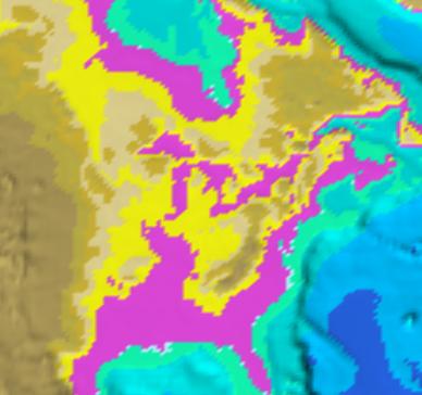
Digital Elevation Model of Great Lakes Basin

lakepond.jpg

The purple shaded elevation indicator is set to a maximum of 200 meters above sea level. At this level, all of the great lakes, except Superior merge into one lake, ponded except for the outlet to the St. Lawrence Seaway.